
ስዕል:Chad Topography.png

Size of this preview: 397 × 599 pixels. Other resolutions: 159 × 240 pixels | 318 × 480 pixels | 509 × 768 pixels | 678 × 1,024 pixels | 1,574 × 2,375 pixels.
ዋና ፋይል (1,574 × 2,375 ፒክስል፤ መጠን፦ 4.01 MB፤ የMIME ዓይነት፦ image/png)
ማጠቃለያ
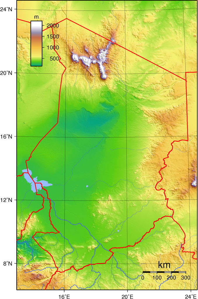
| ማጠቃለያ | Topographic map of Chad. Created with GMT from GLOBE data. |
| ቀን | |
| ምንጭ | Own work |
| አቅራቢው | Sadalmelik |
የፈቃድ አይነት፦
| This work has been released into the public domain by its author, I, Sadalmelik. This applies worldwide. In some countries this may not be legally possible; if so: I, Sadalmelik grants anyone the right to use this work for any purpose, without any conditions, unless such conditions are required by law. |
| Annotations | This image is annotated: View the annotations at Commons |
የፋይሉ ታሪክ
የቀድሞው ዕትም ካለ ቀን/ሰዓቱን በመጫን መመልከት ይቻላል።
| ቀን /ሰዓት | ናሙና | ክልሉ (በpixel) | አቅራቢው | ማጠቃለያ | |
|---|---|---|---|---|---|
| ያሁኑኑ | 19:23, 29 ጁን 2007 | | 1,574 × 2,375 (4.01 MB) | Sadalmelik | Better data/better colours |
| 16:02, 17 ጁን 2007 |  | 1,574 × 2,375 (2.89 MB) | Sadalmelik | {{Information |Description= |Source=self-made |Date= |Author= Sadalmelik }} | |
| 17:54, 14 ጁን 2007 |  | 1,574 × 2,375 (2.74 MB) | Sadalmelik | {{Information |Description=Topographic map of Chad. Created with GMT from GLOBE data. |Source=self-made |Date=June 14, 2007 |Author= Sadalmelik }} Category:Maps of Chad Category:Topographic maps of Africa |
መያያዣዎች
የሚከተለው ገጽ ወደዚሁ ፋይል ተያይዟል፦
ሌሎች ውኪዎች
የሚከተሉት ሌሎች ውኪዎች ይህን ፋይል ይጠቀማሉ፦
- Usage on ast.wikipedia.org
- Usage on avk.wikipedia.org
- Usage on en.wikipedia.org
- Usage on es.wikipedia.org
- Usage on fa.wikipedia.org
- Usage on hu.wikipedia.org
- Usage on ig.wikipedia.org
- Usage on io.wikipedia.org
- Usage on ka.wikipedia.org
- Usage on mdf.wikipedia.org
- Usage on uk.wikipedia.org
- Usage on vep.wikipedia.org