
ስዕል:LocationRomania.png
ከዚህ በላይ ማጉላት አይቻልም።
LocationRomania.png (250 × 115 ፒክስል፤ መጠን፦ 7 KB፤ የMIME ዓይነት፦ image/png)

|
This locator map image could be re-created using vector graphics as an SVG file. This has several advantages; see Commons:Media for cleanup for more information. If an SVG form of this image is available, please upload it and afterwards replace this template with
{{vector version available|new image name}}.
It is recommended to name the SVG file “LocationRomania.svg”—then the template Vector version available (or Vva) does not need the new image name parameter. |
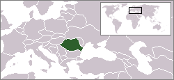
English: Location map of Romania.
Originally created for English Wikipedia by Vardion.
| |
This work has been released into the public domain by its author, Vardion, at the እንግሊዝኛ ውክፔዲያ project. This applies worldwide. In case this is not legally possible: |
የፋይሉ ታሪክ
የቀድሞው ዕትም ካለ ቀን/ሰዓቱን በመጫን መመልከት ይቻላል።
| ቀን /ሰዓት | ናሙና | ክልሉ (በpixel) | አቅራቢው | ማጠቃለያ | |
|---|---|---|---|---|---|
| ያሁኑኑ | 20:45, 2 ኤፕሪል 2009 | | 250 × 115 (7 KB) | D.h | Reverted to version as of 20:37, 2 April 2009 |
| 20:37, 2 ኤፕሪል 2009 |  | 250 × 115 (6 KB) | D.h | Reverted to version as of 23:25, 6 July 2007 | |
| 20:37, 2 ኤፕሪል 2009 |  | 250 × 115 (7 KB) | D.h | Reverted to version as of 20:22, 8 September 2007 | |
| 02:02, 1 ማርች 2009 |  | 1,600 × 1,200 (470 KB) | Olahus | Romania in EU | |
| 20:22, 8 ሴፕቴምበር 2007 |  | 250 × 115 (7 KB) | Skatefreak | Reverted to version as of 11:48, 4 June 2006 | |
| 23:25, 6 ጁላይ 2007 |  | 250 × 115 (6 KB) | Dove | Location of the Romania {{GFDL}} Category:Locator maps for former territories | |
| 11:48, 4 ጁን 2006 |  | 250 × 115 (7 KB) | Rain74 | added Serbia-Montenegro border | |
| 15:08, 9 ዲሴምበር 2004 |  | 250 × 115 (7 KB) | EugeneZelenko | Location map for the Romania.<br/>Originally created for English Wikipedia by Vardion.<br/>{{PD}}<br/>Category:Country locator maps |
መያያዣዎች
ወዲህ ፋይል የተያያዘ ገጽ የለም።
ሌሎች ውኪዎች
የሚከተሉት ሌሎች ውኪዎች ይህን ፋይል ይጠቀማሉ፦
- Usage on arc.wikipedia.org
- Usage on av.wikipedia.org
- Usage on bg.wikipedia.org
- Usage on bo.wikipedia.org
- Usage on bpy.wikipedia.org
- Usage on br.wikipedia.org
- Usage on bs.wikiquote.org
- Usage on ca.wikipedia.org
- Usage on ckb.wikipedia.org
- Usage on de.wikinews.org
- Usage on dsb.wikipedia.org
- Usage on el.wiktionary.org
- Usage on en.wikipedia.org
- Usage on en.wikinews.org
- Usage on en.wikivoyage.org
- Usage on en.wiktionary.org
- Usage on es.wikinews.org
- Usage on eu.wiktionary.org
- Usage on fiu-vro.wikipedia.org
- Usage on fr.wikinews.org
- Usage on gu.wikipedia.org
- Usage on he.wikivoyage.org
- Usage on hu.wikipedia.org
- Usage on hu.wikinews.org
- Usage on ia.wikipedia.org
- Usage on incubator.wikimedia.org
View more global usage of this file.