
ስዕል:Mauretania et Numidia.jpg

ዋና ፋይል (3,509 × 1,383 ፒክስል፤ መጠን፦ 494 KB፤ የMIME ዓይነት፦ image/jpeg)
ማጠቃለያ
Bron: http://www.gottwein.de/latine/map/imp01_afr_nw.jpg
Autor: H.Kiepert, Atlas antiquus, Berlin (Reimer) o.J.
የፈቃድ አይነት፦
|
This work is in the public domain in its country of origin and other countries and areas where the copyright term is the author's life plus 70 years or fewer.
| |
| This file has been identified as being free of known restrictions under copyright law, including all related and neighboring rights. | |
የፋይሉ ታሪክ
የቀድሞው ዕትም ካለ ቀን/ሰዓቱን በመጫን መመልከት ይቻላል።
| ቀን /ሰዓት | ናሙና | ክልሉ (በpixel) | አቅራቢው | ማጠቃለያ | |
|---|---|---|---|---|---|
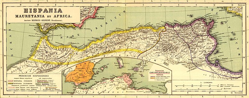
| ያሁኑኑ | 16:54, 3 ጃንዩዌሪ 2011 | 3,509 × 1,383 (494 KB) | Profburp | Meilleure définition. Extrait de la carte: Hispania, Mauretania et Africa. (with) Carthago. (with) Provinciae Carthaginiensibus subditae. Auctore Henrico Kiepert Berolinensi. Geographische Verlagshandlung Dietrich Reimer (Ernst Vohsen) Berlin, Wilhemlstr | |
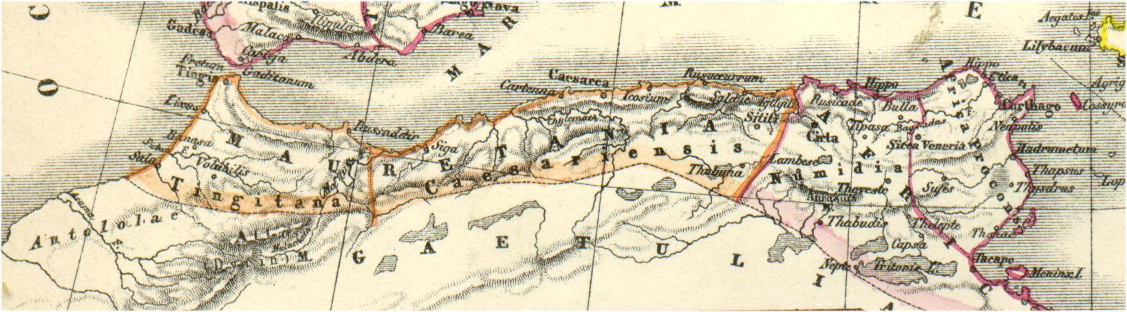
| 18:23, 13 ሜይ 2006 | 1,638 × 454 (175 KB) | Rodriguillo | {{nl|Uit: H.Kiepert, Atlas antiquus, Berlin (Reimer) o.J. Bron: http://www.gottwein.de/latine/map/imp01_afr_nw.jpg Kaart met de ''provinciae'' Mauretania Tingitana, Mauretania Caesariensis en Numidia.}} {{es|Mapa de las provincias roman |
መያያዣዎች
የሚከተለው ገጽ ወደዚሁ ፋይል ተያይዟል፦
ሌሎች ውኪዎች
የሚከተሉት ሌሎች ውኪዎች ይህን ፋይል ይጠቀማሉ፦
- Usage on ar.wikipedia.org
- Usage on ary.wikipedia.org
- Usage on ast.wikipedia.org
- Usage on azb.wikipedia.org
- Usage on az.wikipedia.org
- Usage on be.wikipedia.org
- Usage on br.wikipedia.org
- Usage on ca.wikipedia.org
- Usage on ckb.wikipedia.org
- Usage on cs.wikipedia.org
- Usage on cy.wikipedia.org
- Usage on de.wikipedia.org
- Usage on en.wikipedia.org
- Usage on eo.wikipedia.org
- Usage on es.wikipedia.org
View more global usage of this file.