
ስዕል:Mississippi River map.png

Size of this preview: 800 × 502 pixels. Other resolutions: 320 × 201 pixels | 640 × 402 pixels | 1,024 × 643 pixels | 1,386 × 870 pixels.
ዋና ፋይል (1,386 × 870 ፒክስል፤ መጠን፦ 47 KB፤ የMIME ዓይነት፦ image/png)
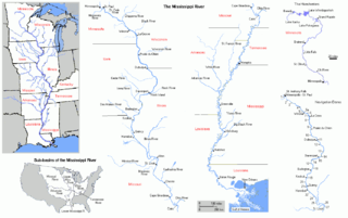
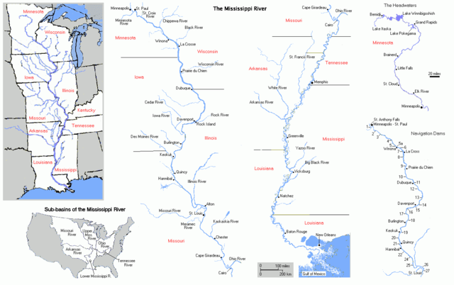
FRom en Wiki by Bluelion. Cite from en wiki:
Map of Mississippi River. I made this map myself and reserve no rights to it. The maps were made by extensively modifying copyright-free maps generated by U.S. Government on-line mapping utilites, either the Department of the Interior's National Atlas of the United States Interactive Map Browser archive copy at the Wayback Machine, or the U.S. Census Bureau's old TIGER Map Browser.
| I, the copyright holder of this work, release this work into the public domain. This applies worldwide. In some countries this may not be legally possible; if so: I grant anyone the right to use this work for any purpose, without any conditions, unless such conditions are required by law. |
የፋይሉ ታሪክ
የቀድሞው ዕትም ካለ ቀን/ሰዓቱን በመጫን መመልከት ይቻላል።
| ቀን /ሰዓት | ናሙና | ክልሉ (በpixel) | አቅራቢው | ማጠቃለያ | |
|---|---|---|---|---|---|
| ያሁኑኑ | 19:10, 27 ጁን 2005 | | 1,386 × 870 (47 KB) | Jan Kronsell | FRom en Wiki by Bluelion. Cite from en wiki: Map of '''''Mississippi River'''''. I made this map myself and '''reserve no rights''' to it. The maps were made by extensively modifying '''copyright-free''' maps generated by U.S. Government on-line mapping |
መያያዣዎች
የሚከተለው ገጽ ወደዚሁ ፋይል ተያይዟል፦
ሌሎች ውኪዎች
የሚከተሉት ሌሎች ውኪዎች ይህን ፋይል ይጠቀማሉ፦
- Usage on an.wikipedia.org
- Usage on bn.wikipedia.org
- Usage on br.wikipedia.org
- Usage on cv.wikipedia.org
- Usage on cy.wikipedia.org
- Usage on da.wikipedia.org
- Usage on eo.wikipedia.org
- Usage on gl.wikipedia.org
- Usage on it.wikipedia.org
- Usage on la.wikipedia.org
- Usage on ml.wikipedia.org
- Usage on ms.wikipedia.org
- Usage on no.wikipedia.org
- Usage on pt.wikipedia.org
- Usage on qu.wikipedia.org
- Usage on roa-tara.wikipedia.org
- Usage on scn.wikipedia.org
- Usage on sl.wikipedia.org
- Usage on sv.wikipedia.org
- Usage on ta.wikipedia.org
- Usage on te.wikipedia.org
- Usage on war.wikipedia.org
- Usage on zh.wikipedia.org