ስዕል:Modis near east.jpg

Page contents not supported in other languages.
ከውክፔዲያ

Modis_near_east.jpg(540 × 540 ፒክስል፤ መጠን፦ 80 KB፤ የMIME ዓይነት፦ image/jpeg)

ይህ ፋይል ከWikimedia Commons የተቀሰመ ነው እና በሌላ ዊኪ ላይ ሊጠቅም ይችላል። በhttps://commons.wikimedia.org/wiki/File:Modis_near_east.jpg ላይ የሚገኘው የፋይሉ መግለጫ ከዚህ በታች ቀርቧል።

ማጠቃለያ

ማጠቃለያ
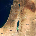
English: Satellite picture of the Near East.
  • Showing: the Palestinian territories, Israel, northwestern Jordan, and southern Syria.
  • West Bank and Dead Sea featured.
ምንጭ http://earthobservatory.nasa.gov/IOTD/view.php?id=879
አቅራቢው NASA

የፈቃድ አይነት፦

Public domain This file is in the public domain in the United States because it was solely created by NASA. NASA copyright policy states that "NASA material is not protected by copyright unless noted". (See Template:PD-USGov, NASA copyright policy page or JPL Image Use Policy.)
Warnings:

የፋይሉ ታሪክ

የቀድሞው ዕትም ካለ ቀን/ሰዓቱን በመጫን መመልከት ይቻላል።

ቀን /ሰዓትናሙናክልሉ (በpixel)አቅራቢውማጠቃለያ
ያሁኑኑ10:56, 1 ፌብሩዌሪ 2009በ10:56, 1 ፌብሩዌሪ 2009 የነበረው ዕትም ናሙና540 × 540 (80 KB)Jyusin{{Information |Description={{en|1=West Bank}} |Source=http://earthobservatory.nasa.gov/IOTD/view.php?id=879 |Author=NASA |Date= |Permission= |other_versions= }} <!--{{ImageUpload|full}}--> Category:West Bank

ወዲህ ፋይል የተያያዘ ገጽ የለም።

ሌሎች ውኪዎች

የሚከተሉት ሌሎች ውኪዎች ይህን ፋይል ይጠቀማሉ፦

ተጨማሪ መረጃ