
ስዕል:Oceania UN Geoscheme - Map of Micronesia.svg

Size of this PNG preview of this SVG file: 800 × 462 pixels. Other resolutions: 320 × 185 pixels | 640 × 370 pixels | 1,024 × 592 pixels | 1,280 × 740 pixels | 2,560 × 1,479 pixels | 900 × 520 pixels.
ዋና ፋይል (የSVG ፋይል፡ በተግባር 900 × 520 ፒክስል፤ መጠን፦ 519 KB)
ማጠቃለያ
This W3C-unspecified vector image was created with Adobe Illustrator.
| ማጠቃለያ |
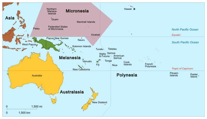
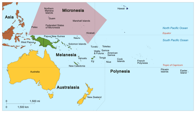
English: Map of Micronesia based on the United Nations geoscheme M49 coding classification devised by the United Nations Statistics Division. SVG format. |
| ቀን | |
| ምንጭ | Own work, derivative of Oceania_ISO_3166-1.svg |
| አቅራቢው |
|
| ሌሎች ዕትሞች |
|


የፈቃድ አይነት፦
I, the copyright holder of this work, hereby publish it under the following license:
This file is licensed under the Creative Commons Attribution-Share Alike 3.0 Unported license.
- You are free:
- to share – to copy, distribute and transmit the work
- to remix – to adapt the work
- Under the following conditions:
- attribution – You must give appropriate credit, provide a link to the license, and indicate if changes were made. You may do so in any reasonable manner, but not in any way that suggests the licensor endorses you or your use.
- share alike – If you remix, transform, or build upon the material, you must distribute your contributions under the same or compatible license as the original.
የፋይሉ ታሪክ
የቀድሞው ዕትም ካለ ቀን/ሰዓቱን በመጫን መመልከት ይቻላል።
| ቀን /ሰዓት | ናሙና | ክልሉ (በpixel) | አቅራቢው | ማጠቃለያ | |
|---|---|---|---|---|---|
| ያሁኑኑ | 04:17, 30 ጃንዩዌሪ 2014 | | 900 × 520 (519 KB) | Cruickshanks | User created page with UploadWizard |
መያያዣዎች
የሚከተለው ገጽ ወደዚሁ ፋይል ተያይዟል፦
ሌሎች ውኪዎች
የሚከተሉት ሌሎች ውኪዎች ይህን ፋይል ይጠቀማሉ፦
- Usage on af.wikipedia.org
- Usage on avk.wikipedia.org
- Usage on bcl.wikipedia.org
- Usage on bg.wikipedia.org
- Usage on en.wikipedia.org
- Wikipedia:Userboxes/Location
- Wikipedia:Userboxes/Location/Oceania
- User:CzechOut
- Wikipedia:WikiProject Micronesia
- Category:WikiProject Micronesia participants
- Wikipedia:Userboxes/Travel
- User:Buaidh/Test4
- Template:User interest Northern Mariana Islands
- Template:User interest Northern Mariana Islands/doc
- Template:User interest Guam
- Template:User interest Guam/doc
- Template:User interest Kiribati
- Template:User interest Kiribati/doc
- Template:User Guam WG
- Template:User WP Kiribati
- Template:User Northern Mariana Islands WG
- Template:User WP Kiribati/doc
- Template:User WP Micronesia
- Template:User WP Micronesia/doc
- Template:User interest Micronesia
- Template:User interest Micronesia/doc
- Category:Wikipedians interested in Micronesia
- Template:User in the Federated States of Micronesia
- Template:User in the Federated States of Micronesia/doc
- Template:User in Guam
- Template:User in Guam/doc
- Template:User in Kiribati
- Template:User in Kiribati/doc
- Template:User in the Marshall Islands
- Template:User in the Marshall Islands/doc
- Template:User WP Federated States of Micronesia
- Template:User WP Federated States of Micronesia/doc
- Template:User WP Marshall Islands
- Template:User WP Marshall Islands/doc
- Template:User in Nauru
- Template:User in Nauru/doc
- Template:User in the Northern Mariana Islands
- Template:User in the Northern Mariana Islands/doc
- Template:User in Palau
- Template:User in Palau/doc
- Template:User WP Nauru
- Template:User WP Nauru/doc
- Template:User WP Palau
- Template:User WP Palau/doc
- Template:User interest Federated States of Micronesia
- Template:User interest Federated States of Micronesia/doc
View more global usage of this file.