
ስዕል:Yugoslavia location map.svg

Size of this PNG preview of this SVG file: 450 × 521 pixels. Other resolutions: 207 × 240 pixels | 415 × 480 pixels | 663 × 768 pixels | 884 × 1,024 pixels | 1,769 × 2,048 pixels.
ዋና ፋይል (የSVG ፋይል፡ በተግባር 450 × 521 ፒክስል፤ መጠን፦ 762 KB)
ማጠቃለያ
| ማጠቃለያ |
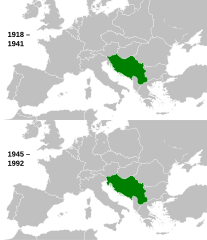
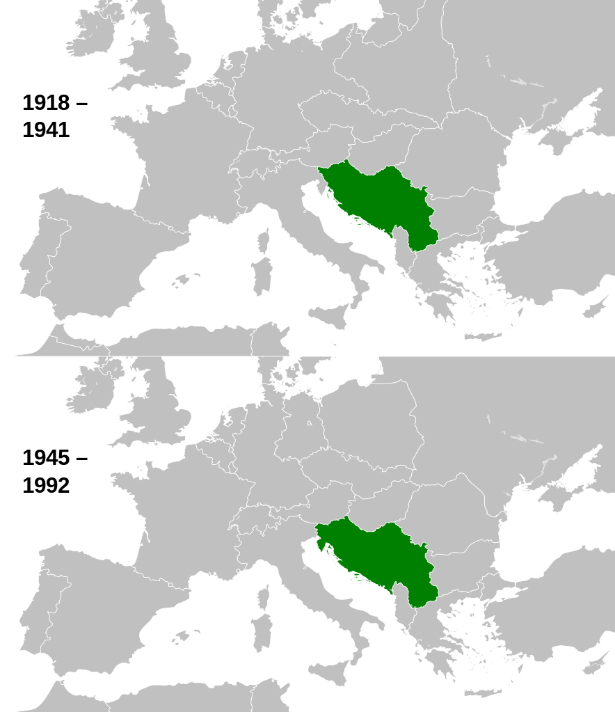
English: This is a map of the evolution of Yugoslavia from 1918 to 1992. |
| ቀን | |
| ምንጭ |
This file was derived from: |
| አቅራቢው |
|

.svg)
የፈቃድ አይነት፦
I, the copyright holder of this work, hereby publish it under the following license:
This file is licensed under the Creative Commons Attribution-Share Alike 3.0 Unported license.
- You are free:
- to share – to copy, distribute and transmit the work
- to remix – to adapt the work
- Under the following conditions:
- attribution – You must give appropriate credit, provide a link to the license, and indicate if changes were made. You may do so in any reasonable manner, but not in any way that suggests the licensor endorses you or your use.
- share alike – If you remix, transform, or build upon the material, you must distribute your contributions under the same or compatible license as the original.
Original upload log
This image is a derivative work of the following images:
- File:History_of_Yugoslavia.svg licensed with Cc-by-sa-3.0
Uploaded with derivativeFX
የፋይሉ ታሪክ
የቀድሞው ዕትም ካለ ቀን/ሰዓቱን በመጫን መመልከት ይቻላል።
| ቀን /ሰዓት | ናሙና | ክልሉ (በpixel) | አቅራቢው | ማጠቃለያ | |
|---|---|---|---|---|---|
| ያሁኑኑ | 10:01, 12 ኦገስት 2013 | | 450 × 521 (762 KB) | Alphathon | Fixed Hungarian pre-1941 border |
| 14:07, 10 ኤፕሪል 2013 |  | 450 × 521 (758 KB) | Alphathon | == {{int:filedesc}} == {{Information |Description={{en|1=This is a map of the evolution of Yugoslavia from 1918 to 1992.}} |date=2013-03-25 15:13:51 |Source={{Derived from|History_of_Yugoslavia.svg|Blank_map_of_Europe_1929-1938.svg|Blank_map_of_Europe_... |
መያያዣዎች
የሚከተለው ገጽ ወደዚሁ ፋይል ተያይዟል፦
ሌሎች ውኪዎች
የሚከተሉት ሌሎች ውኪዎች ይህን ፋይል ይጠቀማሉ፦
- Usage on ang.wikipedia.org
- Usage on ar.wikipedia.org
- Usage on arz.wikipedia.org
- Usage on ast.wikipedia.org
- Usage on ba.wikipedia.org
- Usage on bn.wikipedia.org
- Usage on ca.wikipedia.org
- Usage on csb.wikipedia.org
- Usage on el.wikipedia.org
- Usage on en.wikipedia.org
- Usage on es.wikipedia.org
- Usage on et.wikipedia.org
- Usage on eu.wikipedia.org
- Usage on fa.wikipedia.org
- Usage on fi.wikipedia.org
- Usage on ga.wikipedia.org
- Usage on gd.wikipedia.org
- Usage on gl.wikipedia.org
- Usage on hy.wikipedia.org
- Usage on ia.wikipedia.org
- Usage on id.wikipedia.org
- Usage on ie.wikipedia.org
- Usage on kk.wikipedia.org
- Usage on km.wikipedia.org
- Usage on ko.wikipedia.org
- Usage on ku.wikipedia.org
- Usage on li.wikipedia.org
- Usage on lt.wikipedia.org
- Usage on ms.wikipedia.org
- Usage on mwl.wikipedia.org
- Usage on my.wikipedia.org
- Usage on mzn.wikipedia.org
- Usage on nds-nl.wikipedia.org
- Usage on ne.wikipedia.org
- Usage on no.wikipedia.org
- Usage on pl.wikipedia.org
- Usage on pl.wiktionary.org
- Usage on ps.wikipedia.org
- Usage on pt.wikipedia.org
- Usage on simple.wikipedia.org
- Usage on si.wikipedia.org
- Usage on sk.wikipedia.org
- Usage on sl.wikiquote.org
View more global usage of this file.