
ስዕል:Croatia-Dalmatia.png

Size of this preview: 625 × 599 pixels. Other resolutions: 250 × 240 pixels | 501 × 480 pixels | 801 × 768 pixels | 1,068 × 1,024 pixels | 1,326 × 1,271 pixels.
ዋና ፋይል (1,326 × 1,271 ፒክስል፤ መጠን፦ 78 KB፤ የMIME ዓይነት፦ image/png)
ማጠቃለያ
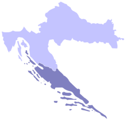
Español: Mapa de Croacia con Dalmacia en azul oscuro
Dalmatia, Croatian region highlighted on map of Croatia.
Made by Shallot who used a map by Morwen.
የፈቃድ አይነት፦

|
Permission is granted to copy, distribute and/or modify this document under the terms of the GNU Free Documentation License, Version 1.2 or any later version published by the Free Software Foundation; with no Invariant Sections, no Front-Cover Texts, and no Back-Cover Texts. A copy of the license is included in the section entitled GNU Free Documentation License. |
| This file is licensed under the Creative Commons Attribution-Share Alike 3.0 Unported license. | ||
| ||
| This licensing tag was added to this file as part of the GFDL licensing update. |
From en.wikipedia [1]:
![[1]](https://en.wikipedia.org/wiki/Image:Croatia-Dalmatia.png)
- 21:49, 19 March 2004 . . Shallot (Talk) . . 200x198 (20267 bytes) (Croatia with Dalmatia highlighted)
የፋይሉ ታሪክ
የቀድሞው ዕትም ካለ ቀን/ሰዓቱን በመጫን መመልከት ይቻላል።
| ቀን /ሰዓት | ናሙና | ክልሉ (በpixel) | አቅራቢው | ማጠቃለያ | |
|---|---|---|---|---|---|
| ያሁኑኑ | 15:11, 30 ኤፕሪል 2012 | | 1,326 × 1,271 (78 KB) | Kirk979 | new, corrected version |
| 22:09, 15 ዲሴምበር 2010 |  | 1,326 × 1,271 (72 KB) | SpeedyGonsales | Both 2008 and 2010 versions of image were not true/equal to original map (island Rab is added which is not really part of Dalmatia), this image now is true to the original map. | |
| 10:59, 19 ኖቬምበር 2010 |  | 1,326 × 1,271 (107 KB) | P. S. Burton | transparent background | |
| 18:06, 12 ሜይ 2008 |  | 1,326 × 1,271 (59 KB) | Пакко | {{Information |Description= |Source= |Date= |Author= |Permission= |other_versions= }} | |
| 13:35, 5 ሜይ 2005 |  | 200 × 198 (20 KB) | Alexg~commonswiki | Dalmatia, Croatian region From the english wikipedia, where stated it is {{GFDL}} |
መያያዣዎች
የሚከተለው ገጽ ወደዚሁ ፋይል ተያይዟል፦
ሌሎች ውኪዎች
የሚከተሉት ሌሎች ውኪዎች ይህን ፋይል ይጠቀማሉ፦
- Usage on af.wikipedia.org
- Usage on als.wikipedia.org
- Usage on an.wikipedia.org
- Usage on be.wikipedia.org
- Usage on br.wikipedia.org
- Usage on bs.wikipedia.org
- Usage on ca.wikipedia.org
- Usage on cs.wikipedia.org
- Usage on cy.wikipedia.org
- Usage on da.wikipedia.org
- Usage on de.wikipedia.org
- Usage on el.wikipedia.org
- Usage on eo.wikipedia.org
- Usage on et.wikipedia.org
- Usage on fur.wikipedia.org
- Usage on fy.wikipedia.org
- Usage on id.wikipedia.org
- Usage on ja.wikipedia.org
- Usage on ka.wikipedia.org
- Usage on ko.wikipedia.org
- Usage on la.wikipedia.org
- Usage on lt.wikipedia.org
- Usage on mk.wikipedia.org
- Usage on ms.wikipedia.org
- Usage on nl.wikipedia.org
- Usage on nn.wikipedia.org
- Usage on os.wikipedia.org
- Usage on pt.wikipedia.org
- Usage on ro.wikipedia.org
- Usage on ru.wikipedia.org
- Usage on sh.wikipedia.org
- Usage on simple.wikipedia.org
- Usage on sk.wikipedia.org
- Usage on sl.wikipedia.org
- Usage on sq.wikipedia.org
- Usage on sw.wikipedia.org
- Usage on tt.wikipedia.org
- Usage on vec.wikipedia.org
- Usage on vi.wikipedia.org
- Usage on zh.wikipedia.org