
ስዕል:England locator map with North East England highlighted.svg

Size of this PNG preview of this SVG file: 494 × 600 pixels. Other resolutions: 198 × 240 pixels | 395 × 480 pixels | 632 × 768 pixels | 843 × 1,024 pixels | 1,686 × 2,048 pixels | 816 × 991 pixels.
ዋና ፋይል (የSVG ፋይል፡ በተግባር 816 × 991 ፒክስል፤ መጠን፦ 469 KB)
| ማጠቃለያ |
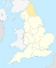
English: Equirectangular projection of England; North East England is highlighted. |
| ቀን | |
| ምንጭ | File:England location map.svg |
| አቅራቢው | |
| የማብዛት ፈቃድ (Reusing this file) |
This file is licensed under the Creative Commons Attribution-Share Alike 3.0 Unported license.
|
የፋይሉ ታሪክ
የቀድሞው ዕትም ካለ ቀን/ሰዓቱን በመጫን መመልከት ይቻላል።
| ቀን /ሰዓት | ናሙና | ክልሉ (በpixel) | አቅራቢው | ማጠቃለያ | |
|---|---|---|---|---|---|
| ያሁኑኑ | 09:34, 8 ኤፕሪል 2010 | | 816 × 991 (469 KB) | Jappalang | {{Information |Description=Equirectangular projection of England; Northumberland is highlighted |Source=File:England location map.svg |Date=2010-04-08 |Author=* File:England location map.svg: Spischot * author: [[User:Jappalang |
መያያዣዎች
የሚከተለው ገጽ ወደዚሁ ፋይል ተያይዟል፦
ሌሎች ውኪዎች
የሚከተሉት ሌሎች ውኪዎች ይህን ፋይል ይጠቀማሉ፦
- Usage on ar.wikipedia.org
- Usage on as.wikipedia.org
- Usage on bh.wikipedia.org
- Usage on blk.wikipedia.org
- Usage on bn.wikipedia.org
- Usage on bs.wikipedia.org
- Usage on ca.wikipedia.org
- Usage on cy.wikipedia.org
- Usage on da.wikipedia.org
- Usage on diq.wikipedia.org
- Usage on dty.wikipedia.org
- Usage on dv.wikipedia.org
- Usage on en.wikipedia.org
- Template:Location map+
- Template:Location map~
- Template:Location map+/doc
- Template:Location map+/sandbox
- Template:Location map+/testcases
- Template:Location map~/sandbox
- Template:Location map+/AlternativeMap
- User:Arjunaraoc/sandbox/SampleMap1
- User:Arjunaraoc/sandbox/SampleMap2
- User:Arjunaraoc/sandbox/SampleMap3
- Usage on en.wikibooks.org
- Usage on en.wikiversity.org
- Usage on fa.wikipedia.org
View more global usage of this file.