
ስዕል:Red Sea topographic map-en.jpg

Size of this preview: 367 × 600 pixels. Other resolutions: 147 × 240 pixels | 293 × 480 pixels | 470 × 768 pixels | 626 × 1,024 pixels | 1,655 × 2,705 pixels.
ዋና ፋይል (1,655 × 2,705 ፒክስል፤ መጠን፦ 1.63 MB፤ የMIME ዓይነት፦ image/jpeg)
ማጠቃለያ
| Camera location | | View this and other nearby images on: OpenStreetMap |
|---|
| ማጠቃለያ |
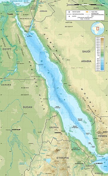
English: Topographic map in English of the Red Sea, UTM projection (WGS84 datum).
Note : for translation purpose, use the SVG version. Français : Carte topographique en anglais de la Mer Rouge, projection UTM (WGS84 datum).
|
||
| ቀን | |||
| ምንጭ | Own work (see complete description on Image:Red_Sea_topographic_map-en.svg) | ||
| አቅራቢው | Eric Gaba (Sting - fr:Sting) | ||
| የማብዛት ፈቃድ (Reusing this file) |
|
||
| ሌሎች ዕትሞች |
[]
|


የፈቃድ አይነት፦
I, the copyright holder of this work, hereby publish it under the following licenses:

|
Permission is granted to copy, distribute and/or modify this document under the terms of the GNU Free Documentation License, Version 1.2 or any later version published by the Free Software Foundation; with no Invariant Sections, no Front-Cover Texts, and no Back-Cover Texts. A copy of the license is included in the section entitled GNU Free Documentation License. |
This file is licensed under the Creative Commons Attribution-Share Alike 4.0 International, 3.0 Unported, 2.5 Generic, 2.0 Generic and 1.0 Generic license.
- You are free:
- to share – to copy, distribute and transmit the work
- to remix – to adapt the work
- Under the following conditions:
- attribution – You must give appropriate credit, provide a link to the license, and indicate if changes were made. You may do so in any reasonable manner, but not in any way that suggests the licensor endorses you or your use.
- share alike – If you remix, transform, or build upon the material, you must distribute your contributions under the same or compatible license as the original.
You may select the license of your choice.
የፋይሉ ታሪክ
የቀድሞው ዕትም ካለ ቀን/ሰዓቱን በመጫን መመልከት ይቻላል።
| ቀን /ሰዓት | ናሙና | ክልሉ (በpixel) | አቅራቢው | ማጠቃለያ | |
|---|---|---|---|---|---|
| ያሁኑኑ | 15:40, 29 ዲሴምበር 2023 | | 1,655 × 2,705 (1.63 MB) | Sting | Without frame |
| 13:37, 19 ጁላይ 2010 |  | 1,655 × 2,705 (1.68 MB) | Sting | Color profile | |
| 04:47, 2 ሴፕቴምበር 2008 |  | 1,655 × 2,705 (1.6 MB) | Sting | New standard colors ; bathymetry from ETOPO1 ; etc. | |
| 19:35, 3 ኤፕሪል 2008 |  | 1,655 × 2,705 (1.67 MB) | Sting | Additional corrections | |
| 13:09, 3 ኤፕሪል 2008 |  | 1,655 × 2,705 (1.71 MB) | Sting | Some names corrections ; some improvements | |
| 11:26, 3 ኤፕሪል 2008 |  | 1,655 × 2,705 (1.67 MB) | Sting | Little correction | |
| 22:32, 2 ኤፕሪል 2008 |  | 1,655 × 2,705 (1.7 MB) | Sting | {{Location|21|00|00|N|38|00|00|E|scale:10000000}} <br/> {{Information |Description={{en|Topographic map in English of the red Sea<br/>''Note :'' for translation purpose, use the SVG version.}} {{fr |
መያያዣዎች
የሚከተለው ገጽ ወደዚሁ ፋይል ተያይዟል፦
ሌሎች ውኪዎች
የሚከተሉት ሌሎች ውኪዎች ይህን ፋይል ይጠቀማሉ፦
- Usage on ami.wikipedia.org
- Usage on ban.wikipedia.org
- Usage on bg.wikipedia.org
- Usage on bh.wikipedia.org
- Usage on bn.wikipedia.org
- Usage on ca.wikipedia.org
- Usage on ckb.wikipedia.org
- Usage on en.wikipedia.org
- Usage on eu.wikipedia.org
- Usage on fa.wikipedia.org
- Usage on fa.wikivoyage.org
- Usage on gu.wikipedia.org
- Usage on hak.wikipedia.org
- Usage on he.wikipedia.org
- Usage on he.wiktionary.org
- Usage on hi.wikipedia.org
- Usage on hr.wikipedia.org
- Usage on ilo.wikipedia.org
- Usage on incubator.wikimedia.org
- Usage on ja.wikipedia.org
- Usage on ja.wikibooks.org
- Usage on ka.wikipedia.org
- Usage on kcg.wikipedia.org
- Usage on kn.wikipedia.org
- Usage on ko.wikipedia.org
- Usage on lfn.wikipedia.org
- Usage on lv.wikipedia.org
- Usage on mai.wikipedia.org
- Usage on ml.wikipedia.org
- Usage on ms.wikipedia.org
- Usage on my.wikipedia.org
- Usage on ne.wikipedia.org
- Usage on no.wikipedia.org
- Usage on olo.wikipedia.org
- Usage on pl.wikipedia.org
View more global usage of this file.