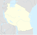
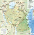
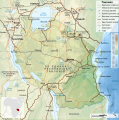
ስዕል:Tanzania location map.svg

Page contents not supported in other languages.
ከውክፔዲያ

ዋና ፋይል(የSVG ፋይል፡ በተግባር 3,302 × 3,143 ፒክስል፤ መጠን፦ 1.04 MB)

ይህ ፋይል ከWikimedia Commons የተቀሰመ ነው እና በሌላ ዊኪ ላይ ሊጠቅም ይችላል። በhttps://commons.wikimedia.org/wiki/File:Tanzania_location_map.svg ላይ የሚገኘው የፋይሉ መግለጫ ከዚህ በታች ቀርቧል።

ማጠቃለያ

ማጠቃለያ
Afrikaans: Liggingkaart van Tanzanië
English: Location map of Tanzania
Español: Mapa de georreferenciación de Tanzania
Français : Carte de géolocalisation de la Tanzanie
Equirectangular projection. 0.25° N, 28° W, 42° E, -13° S. Center : -6.375 35
ቀን (UTC)
ምንጭ
አቅራቢው
ሌሎች ዕትሞች

Derivative works of this file:  Iringa Regionen.png [አርም]

Attribution
(required by the license)
InfoField
© Sémhur / Wikimedia Commons / 
© Sémhur / Wikimedia Commons
SVG
InfoField
 
W3C-validity not checked.
 
This W3C-unspecified vector image was created with Inkscape…important .
This is a retouched picture, which means that it has been digitally altered from its original version. Modifications: Cropped, and prepared for geolocation.. The original can be viewed here: Tanzania map-fr.svg. Modifications made by Sémhur.

Graphic Lab
InfoField
Object location6° 22′ 30″ S, 35° 00′ 00″ E  Heading=1° Kartographer map based on OpenStreetMap.View this and other nearby images on: OpenStreetMapinfo

የፈቃድ አይነት፦

I, the copyright holder of this work, hereby publish it under the following licenses:
w:en:Creative Commons
attribution share alike
This file is licensed under the Creative Commons Attribution-Share Alike Attribution-Share Alike 4.0 International, 3.0 Unported, 2.5 Generic, 2.0 Generic and 1.0 Generic license.
You are free:
  • to share – to copy, distribute and transmit the work
  • to remix – to adapt the work
Under the following conditions:
  • attribution – You must give appropriate credit, provide a link to the license, and indicate if changes were made. You may do so in any reasonable manner, but not in any way that suggests the licensor endorses you or your use.
  • share alike – If you remix, transform, or build upon the material, you must distribute your contributions under the same or compatible license as the original.
Licence Art Libre Copyleft: This work of art is free; you can redistribute it and/or modify it according to terms of the Free Art License. You will find a specimen of this license on the Copyleft Attitude site as well as on other sites.
You may select the license of your choice.

Original upload log

This image is a derivative work of the following images:

  • File:Tanzania_map-fr.svg licensed with Cc-by-sa-3.0,2.5,2.0,1.0, GFDL
    • 2009-03-20T13:30:18Z Sémhur 3096x3113 (3225659 Bytes) Ol Doinyo Lengaï was misplaced
    • 2009-03-20T11:14:35Z Sémhur 3096x3113 (3224368 Bytes) Add location map and few summits.
    • 2009-03-19T17:14:13Z Sémhur 3096x3113 (3099209 Bytes) grrr...
    • 2009-03-19T17:08:18Z Sémhur 3096x3113 (3099244 Bytes) Oups ! It wasn't the valid one.
    • 2009-03-19T17:05:02Z Sémhur 3096x3113 (3122421 Bytes) {{Information |Description={{en|1=Map of [[:en:Tanzania]].}} {{fr|1=Carte de la [[:fr:Tanzanie]].}} {{es|1=Mapa de [[:es:Tanzania]].}} |Source=travail personnel (own work). Sources of data: * Elevations : NASA SRTM3 (public d

Uploaded with derivativeFX

Original upload log

date/time username resolution size edit summary
2009-05-03T08:48:31Z User:Sémhur 3096×2947 828.71Kb borders above waters
2009-05-03T08:45:18Z User:Sémhur 3096×2947 828.72Kb Adding border between Arusha and Manyara
2009-05-01T18:46:42Z User:Sémhur 3096×2947 822.6Kb {{int:summary}} {{Information |Description={{en|1=Location map of [[:en:Tanzania]].}} {{fr|1=Carte de géolocalisation de la [[:fr:Tanzanie]].}} {{es|1=Mapa de georreferenciación de [[:es:Tanzania]].}} Equirectangular projection. 0.25° N, 28° W, 42°

Captions

Add a one-line explanation of what this file represents
Location map of Tanzania

Items portrayed in this file

depicts እንግሊዝኛ

map እንግሊዝኛ

copyright status እንግሊዝኛ

copyrighted እንግሊዝኛ

inception እንግሊዝኛ

1 ሜይ 2009

coordinates of depicted place እንግሊዝኛ

6°S, 35°E

heading እንግሊዝኛ: 1 degree

media type እንግሊዝኛ

image/svg+xml

የፋይሉ ታሪክ

የቀድሞው ዕትም ካለ ቀን/ሰዓቱን በመጫን መመልከት ይቻላል።

ቀን /ሰዓትናሙናክልሉ (በpixel)አቅራቢውማጠቃለያ
ያሁኑኑ20:15, 25 ሜይ 2017በ20:15, 25 ሜይ 2017 የነበረው ዕትም ናሙና3,302 × 3,143 (1.04 MB)SémhurUpdated with Songwe Region
14:16, 13 ዲሴምበር 2013በ14:16, 13 ዲሴምበር 2013 የነበረው ዕትም ናሙና3,096 × 2,947 (1.03 MB)SémhurUpdated with the four new regions
00:30, 25 ጁላይ 2009በ00:30, 25 ጁላይ 2009 የነበረው ዕትም ናሙና3,096 × 2,947 (829 KB)BetacommandBotmove approved by: User:Sémhur This image was moved from File:Tanzania location equirectangular map.svg =={{int:summary}}== {{Information |Description={{en|1=Location map of en:Tanzania.}} {{fr|1=Carte de géolocalisation de la [[:fr:Tanz

የሚከተለው ገጽ ወደዚሁ ፋይል ተያይዟል፦

ሌሎች ውኪዎች

ተጨማሪ መረጃ