
ስዕል:Awashrivermap.png

Size of this preview: 603 × 599 pixels. Other resolutions: 241 × 240 pixels | 483 × 480 pixels | 772 × 768 pixels | 1,203 × 1,196 pixels.
ዋና ፋይል (1,203 × 1,196 ፒክስል፤ መጠን፦ 1.21 MB፤ የMIME ዓይነት፦ image/png)
ማጠቃለያ
| ማጠቃለያ |
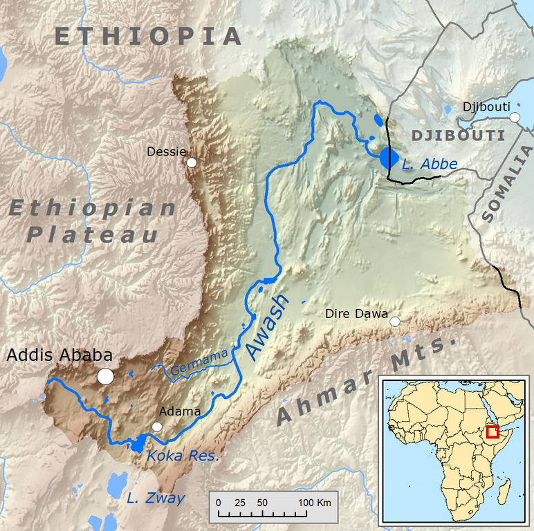
English: Map showing the Awash River drainage basin.
Français : Carte du bassin versant du fleuve Awash (bassin endoréique). |
| ቀን | |
| ምንጭ | Own work, Elevation data from SRTM, drainage basin from GTOPO [1], all other features from Vector Map. Rand McNally "New International Atlas" (1993) used as reference. |
| አቅራቢው | Kmusser |
የፈቃድ አይነት፦
I, the copyright holder of this work, hereby publish it under the following license:
This file is licensed under the Creative Commons Attribution-Share Alike 3.0 Unported license.
- You are free:
- to share – to copy, distribute and transmit the work
- to remix – to adapt the work
- Under the following conditions:
- attribution – You must give appropriate credit, provide a link to the license, and indicate if changes were made. You may do so in any reasonable manner, but not in any way that suggests the licensor endorses you or your use.
- share alike – If you remix, transform, or build upon the material, you must distribute your contributions under the same or compatible license as the original.
የፋይሉ ታሪክ
የቀድሞው ዕትም ካለ ቀን/ሰዓቱን በመጫን መመልከት ይቻላል።
| ቀን /ሰዓት | ናሙና | ክልሉ (በpixel) | አቅራቢው | ማጠቃለያ | |
|---|---|---|---|---|---|
| ያሁኑኑ | 22:29, 1 ዲሴምበር 2018 | | 1,203 × 1,196 (1.21 MB) | Kmusser | Fix to basin boundary and zoom in |
| 18:15, 6 ኦገስት 2010 |  | 1,002 × 1,000 (1.63 MB) | Kmusser | == Summary == {{Information |Description=Map showing the Awash River drainage basin. |Source={{own}}, Elevation data from SRTM, drainage basin from GTOPO [http://eros.usgs.gov/#/Find_Data/Products |
መያያዣዎች
የሚከተለው ገጽ ወደዚሁ ፋይል ተያይዟል፦
ሌሎች ውኪዎች
የሚከተሉት ሌሎች ውኪዎች ይህን ፋይል ይጠቀማሉ፦
- Usage on af.wikipedia.org
- Usage on ar.wikipedia.org
- Usage on as.wikipedia.org
- Usage on azb.wikipedia.org
- Usage on be.wikipedia.org
- Usage on bo.wikipedia.org
- Usage on br.wikipedia.org
- Usage on bs.wikipedia.org
- Usage on cs.wikipedia.org
- Usage on da.wikipedia.org
- Usage on de.wikipedia.org
- Usage on en.wikipedia.org
- Usage on eo.wikipedia.org
- Usage on es.wikipedia.org
- Usage on eu.wikipedia.org
- Usage on fi.wikipedia.org
- Usage on fr.wikipedia.org
- Usage on ha.wikipedia.org
- Usage on he.wikipedia.org
- Usage on hi.wikipedia.org
- Usage on hu.wikipedia.org
- Usage on ilo.wikipedia.org
- Usage on it.wikipedia.org
- Usage on ja.wikipedia.org
- Usage on ko.wikipedia.org
- Usage on la.wikipedia.org
- Usage on lt.wikipedia.org
- Usage on new.wikipedia.org
- Usage on nl.wikipedia.org
- Usage on no.wikipedia.org
- Usage on pa.wikipedia.org
- Usage on pl.wikipedia.org
- Usage on pnb.wikipedia.org
- Usage on ru.wikipedia.org
- Usage on sh.wikipedia.org
- Usage on simple.wikipedia.org
View more global usage of this file.