
ስዕል:Germany sorbian region.png
ከዚህ በላይ ማጉላት አይቻልም።
Germany_sorbian_region.png (188 × 235 ፒክስል፤ መጠን፦ 3 KB፤ የMIME ዓይነት፦ image/png)
ማጠቃለያ
| ማጠቃለያ |
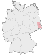
Deutsch: Karte von Deutschland mit den Grenzen der Bundesländer und dem ungefähren Verbreitungegebiet der Sorben rot markiert.
Hornjoserbsce: Korta z čerwjenje markěrowanym sydlenskim rumom Serbow.
English: Map of Germany with borders of its federal states and the red marked region where the Sorbs are living.
Español: En rojo la región aproximada donde viven los sorabos, superpuesta al mapa federal alemán. |
| ምንጭ | Map drawn by User:Dabbelju on basis of Maps generated with http://www.opengeodb.de. |
| አቅራቢው | User:Dabbelju |
| የማብዛት ፈቃድ (Reusing this file) |
GFDL |
የፈቃድ አይነት፦

|
Permission is granted to copy, distribute and/or modify this document under the terms of the GNU Free Documentation License, Version 1.2 or any later version published by the Free Software Foundation; with no Invariant Sections, no Front-Cover Texts, and no Back-Cover Texts. A copy of the license is included in the section entitled GNU Free Documentation License. |
| This file is licensed under the Creative Commons Attribution-Share Alike 3.0 Unported license. | ||
| ||
| This licensing tag was added to this file as part of the GFDL licensing update. |
የፋይሉ ታሪክ
የቀድሞው ዕትም ካለ ቀን/ሰዓቱን በመጫን መመልከት ይቻላል።
| ቀን /ሰዓት | ናሙና | ክልሉ (በpixel) | አቅራቢው | ማጠቃለያ | |
|---|---|---|---|---|---|
| ያሁኑኑ | 20:10, 29 ኦገስት 2007 | | 188 × 235 (3 KB) | 32X | updated by using Image:Karte Deutschland.png, added transparency |
| 21:16, 15 ኖቬምበር 2005 |  | 188 × 235 (5 KB) | Dabbelju | ==Description== {{deutsch}} Karte von Deutschland mit den Grenzen der Bundesländer und dem rot markierten Lebensraum der Sorben. {{english}} Map of Germany with borders of its federal states and the red marked region where the [[:en:Sorbs |
መያያዣዎች
ወዲህ ፋይል የተያያዘ ገጽ የለም።
ሌሎች ውኪዎች
የሚከተሉት ሌሎች ውኪዎች ይህን ፋይል ይጠቀማሉ፦
- Usage on ar.wikipedia.org
- Usage on ast.wikipedia.org
- Usage on ba.wikipedia.org
- Usage on be-tarask.wikipedia.org
- Usage on br.wikipedia.org
- Usage on bs.wikipedia.org
- Usage on cs.wikipedia.org
- Usage on cy.wikipedia.org
- Usage on da.wikipedia.org
- Usage on de.wikipedia.org
- Usage on dsb.wikipedia.org
- Usage on en.wikipedia.org
- Usage on eo.wikipedia.org
- Usage on et.wikipedia.org
- Usage on fa.wikipedia.org
- Usage on fr.wikipedia.org
- Usage on fur.wikipedia.org
- Usage on fy.wikipedia.org
- Usage on hr.wikipedia.org
- Usage on hsb.wikipedia.org
- Usage on hu.wikipedia.org
- Usage on io.wikipedia.org
- Usage on ja.wikipedia.org
- Usage on lt.wikipedia.org
- Usage on mn.wikipedia.org
- Usage on oc.wikipedia.org
- Usage on pl.wikipedia.org
- Usage on ru.wikipedia.org
- Usage on sv.wikipedia.org
- Usage on uk.wikipedia.org
- Usage on xmf.wikipedia.org