
ስዕል:Huanghemap.png

Size of this preview: 800 × 407 pixels. Other resolutions: 320 × 163 pixels | 640 × 326 pixels | 1,024 × 521 pixels | 1,280 × 652 pixels | 2,160 × 1,100 pixels.
ዋና ፋይል (2,160 × 1,100 ፒክስል፤ መጠን፦ 94 KB፤ የMIME ዓይነት፦ image/png)
| ማጠቃለያ |
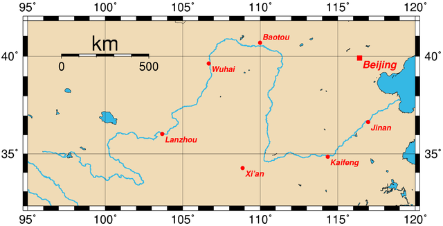
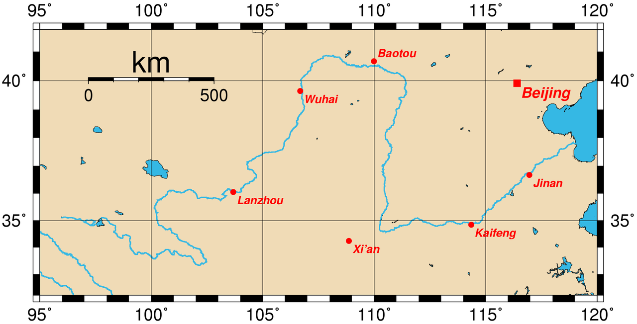
Map of the Huang He and the location of major cities along its course. This map was generated using the Generic Mapping Tools (GMT). The city coordinates (longitude, latitude) used are:
|
| ቀን | |
| ምንጭ | From en wiki |
| አቅራቢው | Upload by Rolfmueller |
| ሌሎች ዕትሞች |
Derivative works of this file: |
External links

|
Permission is granted to copy, distribute and/or modify this document under the terms of the GNU Free Documentation License, Version 1.2 or any later version published by the Free Software Foundation; with no Invariant Sections, no Front-Cover Texts, and no Back-Cover Texts. A copy of the license is included in the section entitled GNU Free Documentation License. |
| This file is licensed under the Creative Commons Attribution-Share Alike 3.0 Unported license. | ||
| ||
| This licensing tag was added to this file as part of the GFDL licensing update. |
የፋይሉ ታሪክ
የቀድሞው ዕትም ካለ ቀን/ሰዓቱን በመጫን መመልከት ይቻላል።
| ቀን /ሰዓት | ናሙና | ክልሉ (በpixel) | አቅራቢው | ማጠቃለያ | |
|---|---|---|---|---|---|
| ያሁኑኑ | 02:50, 31 ጁላይ 2005 | | 2,160 × 1,100 (94 KB) | Fanghong | {{information| |Description =Map of the Huang He and the location of major cities along its course. This map was generated using the Generic Mapping Tools (GMT). The city coordinates (longitude, latitude) used are: *103.6833 36.0500 Lanzhou |
መያያዣዎች
የሚከተለው ገጽ ወደዚሁ ፋይል ተያይዟል፦
ሌሎች ውኪዎች
የሚከተሉት ሌሎች ውኪዎች ይህን ፋይል ይጠቀማሉ፦
- Usage on af.wikipedia.org
- Usage on azb.wikipedia.org
- Usage on bn.wikipedia.org
- Usage on ca.wikipedia.org
- Usage on cs.wikipedia.org
- Usage on cy.wikipedia.org
- Usage on da.wikipedia.org
- Usage on de.wikipedia.org
- Usage on diq.wikipedia.org
- Usage on eo.wikipedia.org
- Usage on hif.wikipedia.org
- Usage on hr.wikipedia.org
- Usage on id.wikipedia.org
- Usage on incubator.wikimedia.org
- Usage on ja.wikipedia.org
- Usage on ko.wikipedia.org
- Usage on kw.wikipedia.org
- Usage on ky.wikipedia.org
- Usage on lb.wikipedia.org
- Usage on lv.wikipedia.org
- Usage on nn.wikipedia.org
- Usage on oc.wikipedia.org
- Usage on pt.wikipedia.org
- Usage on pt.wikibooks.org
- Usage on qu.wikipedia.org
- Usage on ro.wikipedia.org
- Usage on sah.wikipedia.org
- Usage on sh.wikipedia.org
- Usage on simple.wikipedia.org
- Usage on sq.wikipedia.org
- Usage on sr.wikipedia.org
- Usage on sw.wikipedia.org
- Usage on ug.wikipedia.org
- Usage on uk.wikipedia.org
- Usage on ur.wikipedia.org
- Usage on vi.wikipedia.org
- Usage on yi.wikipedia.org
- Usage on za.wikipedia.org
- Usage on zh-min-nan.wikipedia.org
- Usage on zh-yue.wikipedia.org