
ስዕል:PapayaYield.png

Size of this preview: 800 × 488 pixels. Other resolutions: 320 × 195 pixels | 640 × 390 pixels | 1,024 × 624 pixels | 1,490 × 908 pixels.
ዋና ፋይል (1,490 × 908 ፒክስል፤ መጠን፦ 471 KB፤ የMIME ዓይነት፦ image/png)
ማጠቃለያ
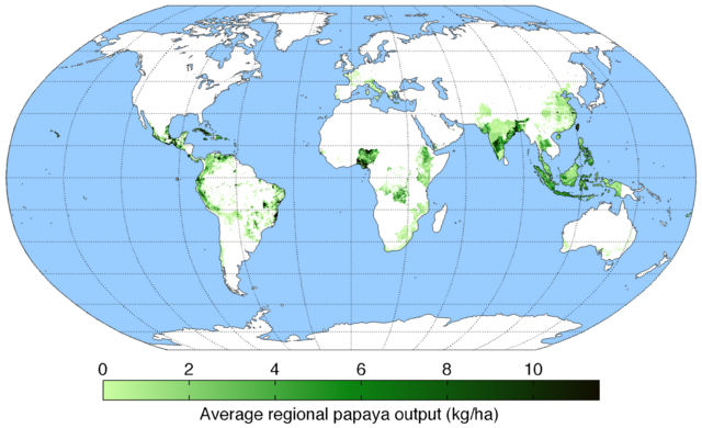
| ማጠቃለያ | Map of papaya production (average percentage of land used for its production times average yield in each grid cell) across the world compiled by the University of Minnesota Institute on the Environment with data from: Monfreda, C., N. Ramankutty, and J.A. Foley. 2008. Farming the planet: 2. Geographic distribution of crop areas, yields, physiological types, and net primary production in the year 2000. Global Biogeochemical Cycles 22: GB1022 |
| ቀን | |
| ምንጭ | Own work |
| አቅራቢው | AndrewMT |
የፈቃድ አይነት፦
I, the copyright holder of this work, hereby publish it under the following license:
This file is licensed under the Creative Commons Attribution-Share Alike 3.0 Unported license.
- You are free:
- to share – to copy, distribute and transmit the work
- to remix – to adapt the work
- Under the following conditions:
- attribution – You must give appropriate credit, provide a link to the license, and indicate if changes were made. You may do so in any reasonable manner, but not in any way that suggests the licensor endorses you or your use.
- share alike – If you remix, transform, or build upon the material, you must distribute your contributions under the same or compatible license as the original.
የፋይሉ ታሪክ
የቀድሞው ዕትም ካለ ቀን/ሰዓቱን በመጫን መመልከት ይቻላል።
| ቀን /ሰዓት | ናሙና | ክልሉ (በpixel) | አቅራቢው | ማጠቃለያ | |
|---|---|---|---|---|---|
| ያሁኑኑ | 14:39, 3 ዲሴምበር 2010 | | 1,490 × 908 (471 KB) | Ras67 | cropped and transparent background |
| 20:51, 12 ሜይ 2010 |  | 1,600 × 960 (487 KB) | AndrewMT | Bigger resolution Category:Papaya Category:Crops Category:Maps | |
| 20:16, 10 ማርች 2010 |  | 800 × 500 (187 KB) | AndrewMT | {{Information |Description={{en|1=Map of pea yield across the world (kg/ha) compiled by the University of Minnesota Institute on the Environment with data from:<br> Monfreda, C., N. Ramankutty, and J.A. Foley. 2008. Farming the planet: 2. Geographic distr |
መያያዣዎች
የሚከተለው ገጽ ወደዚሁ ፋይል ተያይዟል፦
ሌሎች ውኪዎች
የሚከተሉት ሌሎች ውኪዎች ይህን ፋይል ይጠቀማሉ፦