
ስዕል:Detailed SVG map of the Anglophone world.svg

Size of this PNG preview of this SVG file: 800 × 411 pixels. Other resolutions: 320 × 164 pixels | 640 × 329 pixels | 1,024 × 526 pixels | 1,280 × 657 pixels | 2,560 × 1,314 pixels.
ዋና ፋይል (የSVG ፋይል፡ በተግባር 2,560 × 1,314 ፒክስል፤ መጠን፦ 1.38 MB)
ማጠቃለያ
| ማጠቃለያ |
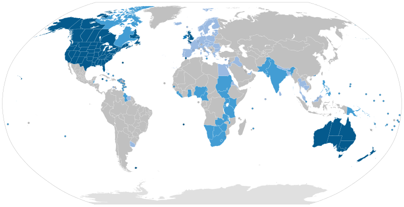
English: Majority native language
Co-official and majority native language
Official but minority native language
Secondary language: spoken as a second language by more than 20% of the population, de facto working language of government, language of instruction in education, etc. |
| ቀን | |
| ምንጭ | Speaker figures based on Ethnologue and other sources. Blank map: File:BlankMap-World6-Subdivisions.svg |
| አቅራቢው | Jpthefish |
የፈቃድ አይነት፦
I, the copyright holder of this work, hereby publish it under the following license:
This file is licensed under the Creative Commons Attribution-Share Alike 4.0 International license.
- You are free:
- to share – to copy, distribute and transmit the work
- to remix – to adapt the work
- Under the following conditions:
- attribution – You must give appropriate credit, provide a link to the license, and indicate if changes were made. You may do so in any reasonable manner, but not in any way that suggests the licensor endorses you or your use.
- share alike – If you remix, transform, or build upon the material, you must distribute your contributions under the same or compatible license as the original.
የፋይሉ ታሪክ
የቀድሞው ዕትም ካለ ቀን/ሰዓቱን በመጫን መመልከት ይቻላል።
| ቀን /ሰዓት | ናሙና | ክልሉ (በpixel) | አቅራቢው | ማጠቃለያ | |
|---|---|---|---|---|---|
| ያሁኑኑ | 09:51, 26 ኦገስት 2023 | | 2,560 × 1,314 (1.38 MB) | Kwamikagami | rv: you just removed light blue, which we use on other maps |
| 01:35, 26 ኦገስት 2023 |  | 2,560 × 1,314 (1.36 MB) | Jpthefish | Reverted to version as of 01:23, 3 July 2020 (UTC) Forgive me if I am mistaken, but I have not seen sources to corroborate the light blue coloring of the EU, SE Asia, or other regions. The light blue color in my other maps was previously reserved for lanauges with cultural or secondary status - that is, a historically significant language and/or a language spoken by over 20% of the native population. I am open to changes though, as long as they are consistent across all SVG maps and reflect a... | |
| 05:42, 9 ኦገስት 2023 |  | 2,560 × 1,314 (1.38 MB) | Kwamikagami | some countries marked as majority English were majority creole | |
| 06:33, 15 ጃንዩዌሪ 2023 |  | 2,560 × 1,314 (1.38 MB) | Kwamikagami | clean up Quebec; Faroes assumed | |
| 05:50, 15 ጃንዩዌሪ 2023 |  | 2,560 × 1,314 (1.38 MB) | Kwamikagami | 2nd language >20%, & de facto govt working language, per Ethnologue. | |
| 01:23, 3 ጁላይ 2020 |  | 2,560 × 1,314 (1.36 MB) | Jpthefish | New section | |
| 22:47, 8 ጁን 2020 |  | 2,560 × 1,314 (1.36 MB) | Jpthefish | Lighter secondary colors | |
| 17:17, 25 ሜይ 2020 |  | 2,560 × 1,314 (1.36 MB) | Jpthefish | edit Channel Islands | |
| 18:19, 8 ሜይ 2020 |  | 2,560 × 1,314 (1.36 MB) | Jpthefish | Add Cameroon | |
| 02:15, 8 ሜይ 2020 |  | 2,560 × 1,314 (1.36 MB) | Jpthefish | Uploaded own work with UploadWizard |
መያያዣዎች
ወዲህ ፋይል የተያያዘ ገጽ የለም።
ሌሎች ውኪዎች
የሚከተሉት ሌሎች ውኪዎች ይህን ፋይል ይጠቀማሉ፦
- Usage on af.wikipedia.org
- Usage on ang.wikipedia.org
- Usage on ar.wikipedia.org
- Usage on ast.wikipedia.org
- Usage on av.wikipedia.org
- Usage on az.wikipedia.org
- Usage on ba.wikipedia.org
- Usage on be.wikipedia.org
- Usage on bg.wikipedia.org
- Usage on bn.wikipedia.org
- Usage on br.wikipedia.org
- Usage on cv.wikipedia.org
- Usage on en.wikipedia.org
- Usage on en.wikibooks.org
- Usage on es.wikipedia.org
- Usage on fa.wikipedia.org
- Usage on fr.wikipedia.org
- Usage on ga.wikipedia.org
- Usage on guc.wikipedia.org
- Usage on he.wikipedia.org
- Usage on hr.wikipedia.org
- Usage on hy.wikipedia.org
- Usage on id.wikipedia.org
- Usage on incubator.wikimedia.org
- Usage on it.wikipedia.org
View more global usage of this file.