
ስዕል:Krim 2014 de.svg

Size of this PNG preview of this SVG file: 665 × 441 pixels. Other resolutions: 320 × 212 pixels | 640 × 424 pixels | 1,024 × 679 pixels | 1,280 × 849 pixels | 2,560 × 1,698 pixels.
ዋና ፋይል (የSVG ፋይል፡ በተግባር 665 × 441 ፒክስል፤ መጠን፦ 103 KB)
ማጠቃለያ
| ማጠቃለያ |
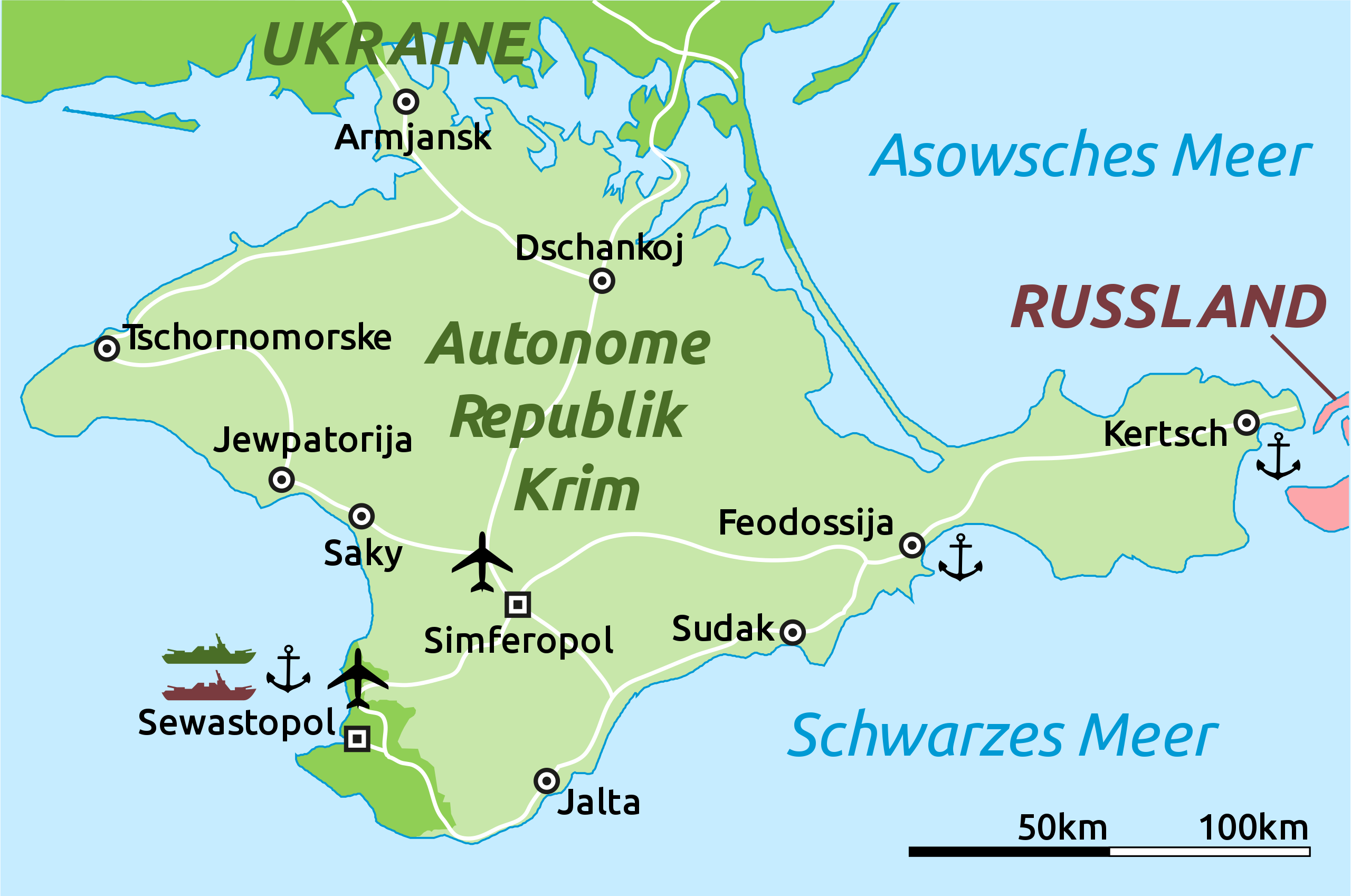
Deutsch: Karte der Krim-Republik.
English: Map of the Autonomous Republic of Crimea and of Sevastopol, Ukraine. |
| ቀን | |
| ምንጭ |
This file was derived from: |
| አቅራቢው |
Original: ቬክተር: Furfur and Martin Kraft |
| ሌሎች ዕትሞች |
|
| SVG genesis | This locator map was created with Adobe Illustrator. |

የፈቃድ አይነት፦
I, the copyright holder of this work, hereby publish it under the following license:
| This file is made available under the Creative Commons CC0 1.0 Universal Public Domain Dedication. | |
| The person who associated a work with this deed has dedicated the work to the public domain by waiving all of their rights to the work worldwide under copyright law, including all related and neighboring rights, to the extent allowed by law. You can copy, modify, distribute and perform the work, even for commercial purposes, all without asking permission.
|
Original upload log
This image is a derivative work of the following images:
- Crimea republic map.png licensed with Cc-zero
- 2012-09-06T09:53:36Z PANONIAN 1031x684 (62218 Bytes) corrected Sevastopol border
- 2012-08-30T11:55:15Z PANONIAN 1031x684 (61885 Bytes) {{Information |Description=Map of the Autonomous Republic Crimea, Ukraine. |Source={{own}} |Date=2012 |Author= [[User:PANONIAN|PANONIAN]] |Permission= |other_versions= }}
Uploaded with derivativeFX
የፋይሉ ታሪክ
የቀድሞው ዕትም ካለ ቀን/ሰዓቱን በመጫን መመልከት ይቻላል።
| ቀን /ሰዓት | ናሙና | ክልሉ (በpixel) | አቅራቢው | ማጠቃለያ | |
|---|---|---|---|---|---|
| ያሁኑኑ | 16:52, 5 ማርች 2014 | | 665 × 441 (103 KB) | Schwarzorange | moved "Saky" closer to Saky |
| 19:10, 4 ማርች 2014 |  | 665 × 441 (103 KB) | Martin Kraft | Maßstab, +Tschornomorske, diverse kleiner Optimierungen | |
| 10:37, 4 ማርች 2014 |  | 665 × 441 (103 KB) | Martin Kraft | Dzhankoi -> Dschankoj | |
| 11:25, 3 ማርች 2014 |  | 665 × 441 (103 KB) | Martin Kraft | Straßen, weiter Städte, Farben | |
| 08:39, 3 ማርች 2014 |  | 665 × 441 (105 KB) | Martin Kraft | Pfade aufgeräumt. Dateigröße halbiert. | |
| 07:42, 3 ማርች 2014 |  | 665 × 441 (229 KB) | Furfur | Sinferopol -> Simferopol | |
| 22:39, 2 ማርች 2014 |  | 665 × 441 (225 KB) | Martin Kraft | +Flughafen | |
| 22:27, 2 ማርች 2014 |  | 665 × 441 (226 KB) | Martin Kraft | Ohne Schraffur ist doch irgendwie besser | |
| 22:14, 2 ማርች 2014 |  | 665 × 441 (230 KB) | Martin Kraft | Karte komplett überarbeitet. Bei Nichtgefallen einfach revertieren, dann stelle ich sie seperat ein | |
| 20:44, 2 ማርች 2014 |  | 665 × 441 (313 KB) | Furfur | verbessert |
መያያዣዎች
ወዲህ ፋይል የተያያዘ ገጽ የለም።
ሌሎች ውኪዎች
የሚከተሉት ሌሎች ውኪዎች ይህን ፋይል ይጠቀማሉ፦
- Usage on de.wikipedia.org
- Usage on fr.wikipedia.org
- Usage on sr.wikinews.org