
ስዕል:Balkan peninsula line.jpg
ከዚህ በላይ ማጉላት አይቻልም።
Balkan_peninsula_line.jpg (558 × 530 ፒክስል፤ መጠን፦ 169 KB፤ የMIME ዓይነት፦ image/jpeg)
ማጠቃለያ
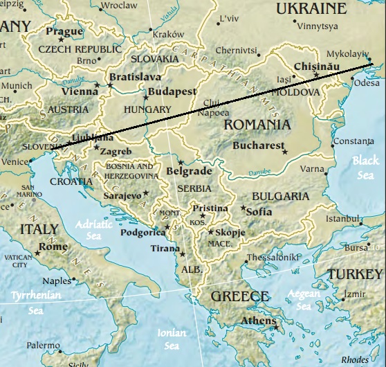
| ማጠቃለያ | Map of the Balkan peninsula, showing the line stretching from the northernmost point of the Adriatic to the northernmost point of the Black Sea. Made from Europe map at The Central Intelligence Agency World Factbook, which is in the public domain. |
| ምንጭ | https://www.cia.gov/library/publications/the-world-factbook//graphics/ref_maps/physical/jpg/europe.jpg |
| አቅራቢው | CIA |
| ሌሎች ዕትሞች |
|
.jpg)
የፈቃድ አይነት፦
This image is in the public domain because it contains materials that originally came from the United States Central Intelligence Agency's World Factbook.
|
 |

|
This map image could be re-created using vector graphics as an SVG file. This has several advantages; see Commons:Media for cleanup for more information. If an SVG form of this image is available, please upload it and afterwards replace this template with
{{vector version available|new image name}}.
It is recommended to name the SVG file “Balkan peninsula line.svg”—then the template Vector version available (or Vva) does not need the new image name parameter. |


የፋይሉ ታሪክ
የቀድሞው ዕትም ካለ ቀን/ሰዓቱን በመጫን መመልከት ይቻላል።
| ቀን /ሰዓት | ናሙና | ክልሉ (በpixel) | አቅራቢው | ማጠቃለያ | |
|---|---|---|---|---|---|
| ያሁኑኑ | 12:27, 16 ጃንዩዌሪ 2014 | | 558 × 530 (169 KB) | Denniss | Reverted to version as of 22:51, 26 December 2013 |
| 21:21, 15 ጃንዩዌሪ 2014 |  | 348 × 382 (43 KB) | Ivan VA | stop vandalizing maps | |
| 22:51, 26 ዲሴምበር 2013 |  | 558 × 530 (169 KB) | No More Cats | Please don't revert to outdated versions of maps | |
| 22:43, 26 ዲሴምበር 2013 |  | 348 × 382 (43 KB) | Nikola Smolenski | Reverted to version as of 19:13, 3 November 2006 | |
| 16:06, 17 ዲሴምበር 2013 |  | 558 × 530 (169 KB) | No More Cats | Map of the Balkan peninsula, showing the line stretching from the northernmost point of the Adriatic to the northernmost point of the Black Sea. Made from most recent map at [https://www.cia.gov/cia/publications/factbook/reference_maps/jpg/europe.jpg]. | |
| 19:13, 3 ኖቬምበር 2006 |  | 348 × 382 (43 KB) | Nikola Smolenski | Map of the Balkan peninsula, showing the line stretching from the northernmost point of the Adriatic to the northernmost point of the Black Sea. Made from map at [https://www.cia.gov/cia/publications/factbook/reference_maps/jpg/europe.jpg]. |
መያያዣዎች
ወዲህ ፋይል የተያያዘ ገጽ የለም።