
ስዕል:Arabian Sea map.png
Size of this preview: 635 × 600 pixels. Other resolutions: 254 × 240 pixels | 508 × 480 pixels | 797 × 753 pixels.
ዋና ፋይል (797 × 753 ፒክስል፤ መጠን፦ 147 KB፤ የMIME ዓይነት፦ image/png)
ማጠቃለያ
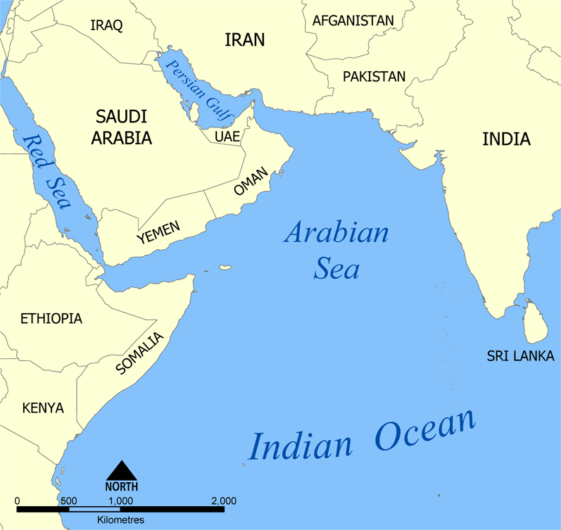
| ማጠቃለያ | A map showing the location of the Arabian Sea in the Indian Ocean. Created by NormanEinstein, July 19, 2005. |
| ቀን | |
| ምንጭ | Self-published work by NormanEinstein |
| አቅራቢው | NormanEinstein, Ras67 |
| ሌሎች ዕትሞች |
Derivative works of this file: |
የፈቃድ አይነት፦
I, the copyright holder of this work, hereby publish it under the following licenses:

|
Permission is granted to copy, distribute and/or modify this document under the terms of the GNU Free Documentation License, Version 1.2 or any later version published by the Free Software Foundation; with no Invariant Sections, no Front-Cover Texts, and no Back-Cover Texts. A copy of the license is included in the section entitled GNU Free Documentation License. |
| This file is licensed under the Creative Commons Attribution-Share Alike 3.0 Unported license. | ||
| ||
| This licensing tag was added to this file as part of the GFDL licensing update. |
You may select the license of your choice.
የፋይሉ ታሪክ
የቀድሞው ዕትም ካለ ቀን/ሰዓቱን በመጫን መመልከት ይቻላል።
| ቀን /ሰዓት | ናሙና | ክልሉ (በpixel) | አቅራቢው | ማጠቃለያ | |
|---|---|---|---|---|---|
| ያሁኑኑ | 11:54, 13 ጁላይ 2020 | | 797 × 753 (147 KB) | Kzl55 | Restored longstanding version |
| 14:13, 21 ማርች 2020 |  | 635 × 600 (155 KB) | Noseisnostriledd | ctl | |
| 23:42, 19 ማርች 2020 |  | 635 × 600 (155 KB) | Noseisnostriledd | regional sea | |
| 19:58, 28 ዲሴምበር 2019 |  | 797 × 753 (200 KB) | Noseisnostriledd | Add detail | |
| 13:20, 14 ኤፕሪል 2011 |  | 797 × 753 (147 KB) | Ras67 | cropped and squeezed | |
| 14:30, 19 ጁላይ 2005 |  | 800 × 757 (223 KB) | NormanEinstein | A map showing the location of the Arabian Sea in the Indian Ocean. Created by NormanEinstein, Jully 19, 2005. {{GFDL-self}} Category:Maps of seas | |
| 14:30, 19 ጁላይ 2005 |  | 800 × 757 (223 KB) | NormanEinstein | A map showing the location of the Arabian Sea in the Indian Ocean. Created by NormanEinstein, Jully 19, 2005. {{GFDL-self}} Category:Maps of seas |
መያያዣዎች
የሚከተለው ገጽ ወደዚሁ ፋይል ተያይዟል፦
ሌሎች ውኪዎች
የሚከተሉት ሌሎች ውኪዎች ይህን ፋይል ይጠቀማሉ፦
- Usage on af.wikipedia.org
- Usage on ar.wikipedia.org
- Usage on ast.wikipedia.org
- Usage on as.wikipedia.org
- Usage on az.wikipedia.org
- Usage on az.wiktionary.org
- Usage on be-tarask.wikipedia.org
- Usage on bg.wikipedia.org
- Usage on bh.wikipedia.org
- Usage on bs.wikipedia.org
- Usage on bxr.wikipedia.org
- Usage on ckb.wikipedia.org
- Usage on cs.wikipedia.org
- Usage on cv.wikipedia.org
- Usage on cy.wikipedia.org
- Usage on da.wikipedia.org
- Usage on de.wikipedia.org
- Usage on diq.wikipedia.org
- Usage on dv.wikipedia.org
- Usage on en.wikipedia.org
- Usage on eo.wikipedia.org
- Usage on es.wikipedia.org
- Usage on eu.wikipedia.org
- Usage on fa.wikipedia.org
- Usage on fi.wikipedia.org
View more global usage of this file.