
ስዕል:Karte Bodensee V2.png

Size of this preview: 800 × 514 pixels. Other resolutions: 320 × 206 pixels | 640 × 411 pixels | 1,024 × 658 pixels | 1,280 × 823 pixels | 2,066 × 1,328 pixels.
ዋና ፋይል (2,066 × 1,328 ፒክስል፤ መጠን፦ 838 KB፤ የMIME ዓይነት፦ image/png)
|
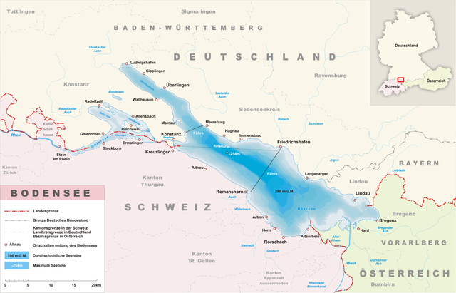
Deutsch: Karte des Bodensee
English: Map of the Lake Constance
Français : Carte du Lac de Constance
Русский: Карта Боденского озера
|other_versions=Image:Karte Bodensee V3.png (colours a bit stronger)

|
Permission is granted to copy, distribute and/or modify this document under the terms of the GNU Free Documentation License, Version 1.2 or any later version published by the Free Software Foundation; with no Invariant Sections, no Front-Cover Texts, and no Back-Cover Texts. A copy of the license is included in the section entitled GNU Free Documentation License. |
| This file is licensed under the Creative Commons Attribution-Share Alike 3.0 Unported license. | ||
| ||
| This licensing tag was added to this file as part of the GFDL licensing update. |
የፋይሉ ታሪክ
የቀድሞው ዕትም ካለ ቀን/ሰዓቱን በመጫን መመልከት ይቻላል።
| ቀን /ሰዓት | ናሙና | ክልሉ (በpixel) | አቅራቢው | ማጠቃለያ | |
|---|---|---|---|---|---|
| ያሁኑኑ | 19:09, 4 ጃንዩዌሪ 2013 | | 2,066 × 1,328 (838 KB) | Tschubby | {{Information |Description= |Source= |Date= |Author= |Permission= |other_versions= }} |
| 19:03, 4 ጃንዩዌሪ 2013 |  | 2,066 × 1,328 (829 KB) | Tschubby | {{Information |Description= |Source= |Date= |Author= |Permission= |other_versions= }} | |
| 18:22, 27 ጁን 2012 |  | 2,066 × 1,328 (844 KB) | Tschubby | {{Information |Description= |Source= |Date= |Author= |Permission= |other_versions= }} | |
| 08:39, 27 ጁን 2012 |  | 2,066 × 1,328 (844 KB) | Tschubby | {{Information |Description= |Source= |Date= |Author= |Permission= |other_versions= }} | |
| 08:32, 10 ፌብሩዌሪ 2008 |  | 2,066 × 1,328 (831 KB) | Tschubby | {{Information |Description= |Source=eigene Arbeit |Date= |Author= Tschubby |Permission= |other_versions= }} | |
| 12:12, 6 ጃንዩዌሪ 2007 |  | 1,771 × 1,138 (475 KB) | Tschubby | ||
| 20:23, 4 ጃንዩዌሪ 2007 |  | 1,328 × 854 (322 KB) | Tschubby | ||
| 18:33, 4 ጃንዩዌሪ 2007 |  | 1,328 × 854 (316 KB) | Tschubby | ||
| 21:35, 3 ጃንዩዌሪ 2007 |  | 1,181 × 759 (258 KB) | Tschubby | {{de|Karte des Bodensee}} {{en|Map of the Lake Constance}} {{fr|Un cart de lake de Canstance}} {{ru|Карта Боденского озера}} *de: Quelle: selbstgezeichnet von Tschubby *en: Source: German Wikipedia, uploaded |
መያያዣዎች
የሚከተለው ገጽ ወደዚሁ ፋይል ተያይዟል፦
ሌሎች ውኪዎች
የሚከተሉት ሌሎች ውኪዎች ይህን ፋይል ይጠቀማሉ፦
- Usage on af.wikipedia.org
- Usage on ar.wikipedia.org
- Usage on arz.wikipedia.org
- Usage on bg.wikipedia.org
- Usage on de.wikipedia.org
- Bodensee
- Liste von Seen in Deutschland
- Seegfrörnen des Bodensees
- Portal:Schweiz/Galerie
- Portal:Bodensee/Einleitung
- Portal:Bodensee
- Wikipedia:Kandidaten für exzellente Bilder/Archiv2007/1
- Datei:Karte Bodensee V2.png
- Diskussion:Aach (Bodensee, Arbon)
- Wikipedia:Exzellente Bilder/Karten und Satellitenbilder
- Benutzer Diskussion:Tschubby/Archiv 2008
- Übereinkommen über den Schutz des Bodensees gegen Verunreinigung
- Portal:Schweiz/Galerie/Bilder
- Benutzer:Tschubby/Gewässer
- Wikipedia:Bodensee
- S-Bahn Bodensee
- Benutzer:Bulwersator/Echo/Maps/Lakes
- Benutzer:Anarabert/Liste der Fließgewässer im Flusssystem Rhein
- Usage on dsb.wikipedia.org
- Usage on en.wikipedia.org
- Usage on en.wikivoyage.org
- Usage on es.wikipedia.org
- Usage on es.wikibooks.org
- Usage on fr.wikipedia.org
- Usage on hsb.wikipedia.org
- Usage on ia.wikipedia.org
- Usage on it.wikipedia.org
- Usage on ka.wikipedia.org
- Usage on nl.wikipedia.org
- Usage on pl.wikipedia.org
- Usage on ru.wikipedia.org
- Usage on sk.wikipedia.org
- Usage on sq.wikipedia.org
- Usage on sv.wikipedia.org
- Usage on sw.wikipedia.org
- Usage on uz.wikipedia.org
- Usage on www.wikidata.org
- Usage on xmf.wikipedia.org