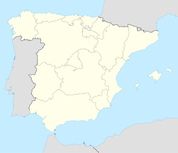
ስዕል:Spain location map.svg
Appearance

Size of this PNG preview of this SVG file: 699 × 600 pixels. Other resolutions: 280 × 240 pixels | 559 × 480 pixels | 895 × 768 pixels | 1,193 × 1,024 pixels | 2,387 × 2,048 pixels | 1,184 × 1,016 pixels.
ዋና ፋይል (የSVG ፋይል፡ በተግባር 1,184 × 1,016 ፒክስል፤ መጠን፦ 536 KB)
የፋይሉ ታሪክ
የቀድሞው ዕትም ካለ ቀን/ሰዓቱን በመጫን መመልከት ይቻላል።
| ቀን /ሰዓት | ናሙና | ክልሉ (በpixel) | አቅራቢው | ማጠቃለያ | |
|---|---|---|---|---|---|
| ያሁኑኑ | 14:23, 7 ጁላይ 2008 |  | 1,184 × 1,016 (536 KB) | NordNordWest | |
| 13:58, 4 ጁላይ 2008 |  | 1,184 × 1,016 (785 KB) | NordNordWest | corrected | |
| 13:54, 4 ጁላይ 2008 |  | 1,184 × 1,016 (791 KB) | NordNordWest | {{Information |Description= {{de|Positionskarte von Spanien}} Quadratische Plattkarte, N-S-Streckung 130 %. Geographische Begrenzung der Karte: * N: 44.4° N * S: 34.7° N * W: 9.9° W * O: 4.8° O {{en|Location map of Spain} |
መያያዣዎች
የሚከተሉ 44 ገጾች ወደዚሁ ፋይል ተያይዘዋል፦
- ሉጎ
- ላ አልሙኒያ ዴ ዶኛ ጎዲና
- ሚራንዳ ዴ ኤብሮ
- ማላጋ
- ሜሊያ
- ሜሪዳ፣ እስፓንያ
- ሜዲና ዴ ሪዮ ሴኮ
- ሞንሬያል ዴ አሪዛ
- ሞንቴርሞሶ
- ሞንዞን
- ሬቶርቲዮ (ካምፖ ዴ ኤንሜዲዮ)
- ሰቪያ
- ሳንቲያጎ ዴ ኮምፖስቴላ
- ሳጉንቶ
- ሴሊሴስ
- ሴውታ
- ቢልባው
- ባርሴሎና
- ባያዶሊድ
- ባዮና
- ቤናቬንቴ፣ ዛሞራ
- ቫለንሲያ
- ቱዴላ
- ታላቬራ ላ ቪዬሓ
- ታላቬራ ዴ ላ ሬና
- ታሪፋ
- ታራጎና
- ታርዳሖስ
- ታፋላ
- ቶሌዶ
- ናቪያ
- ኖያ
- አ ፖብራ ዴ ትሪቬስ
- አልማዛን
- አምፖስታ
- ኦረንሴ
- ኦሶርኖ ላ ማዮር
- ካርታሔና
- ካዲዝ
- ኮርዶባ
- ዛራጎዛ
- ግራናዳ
- ፍሬኄናል ዴ ላ ሲዬራ
- መለጠፊያ:Location map እስፓንያ
ሌሎች ውኪዎች
የሚከተሉት ሌሎች ውኪዎች ይህን ፋይል ይጠቀማሉ፦
- Usage on ace.wikipedia.org
- Usage on af.wikipedia.org
- Cadaqués
- Alt Empordà
- Almazán
- Ágreda
- San Leonardo de Yagüe
- Abejar
- Adradas
- Alconaba
- Alcubilla de las Peñas
- Aldealafuente
- Alcubilla de Avellaneda
- Aldealices
- Almajano
- Yelo
- Aldealpozo
- Aldealseñor
- Alentisque
- Aliud
- Almaluez
- Almarza
- Cubilla
- Covaleda
- Ciria
- Cigudosa
- Dévanos
- Cihuela
- Coscurita
- Barca
- Nepas
- Nolay
- Noviercas
- Liceras
- La Losilla
- Portillo de Soria
- Oncala
- Ólvega
- Rioseco de Soria
- La Riba de Escalote
- Renieblas
- Quintana Redonda
- Los Rábanos
- Recuerda
- Rebollar
- Almazul
- Baraona
- Blacos
- Calatañazor
- Candilichera
View more global usage of this file.


