
ስዕል:Africa-countries-southern.svg

Size of this PNG preview of this SVG file: 384 × 420 pixels. Other resolutions: 219 × 240 pixels | 439 × 480 pixels | 702 × 768 pixels | 936 × 1,024 pixels | 1,872 × 2,048 pixels.
ዋና ፋይል (የSVG ፋይል፡ በተግባር 384 × 420 ፒክስል፤ መጠን፦ 26 KB)
ማጠቃለያ
| ማጠቃለያ |
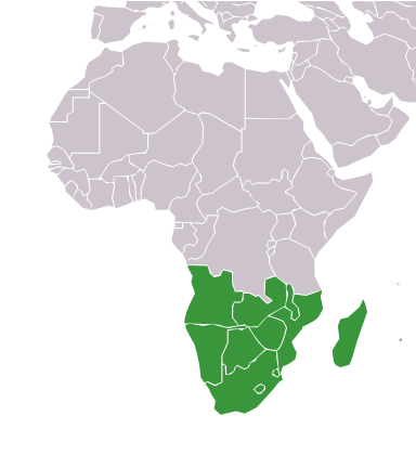
English: Map with the countries of Southern Africa highlighted:
|
| ቀን | |
| ምንጭ |
This file was derived from: |
| አቅራቢው | ReneeWrites |
| ሌሎች ዕትሞች | |
| SVG genesis | This locator map was created with Adobe Illustrator. |


የፈቃድ አይነት፦
This file is licensed under the Creative Commons Attribution 4.0 International license.
- You are free:
- to share – to copy, distribute and transmit the work
- to remix – to adapt the work
- Under the following conditions:
- attribution – You must give appropriate credit, provide a link to the license, and indicate if changes were made. You may do so in any reasonable manner, but not in any way that suggests the licensor endorses you or your use.
የፋይሉ ታሪክ
የቀድሞው ዕትም ካለ ቀን/ሰዓቱን በመጫን መመልከት ይቻላል።
| ቀን /ሰዓት | ናሙና | ክልሉ (በpixel) | አቅራቢው | ማጠቃለያ | |
|---|---|---|---|---|---|
| ያሁኑኑ | 00:35, 13 ዲሴምበር 2023 | | 384 × 420 (26 KB) | ReneeWrites | Small fix |
| 18:20, 12 ዲሴምበር 2023 |  | 384 × 420 (26 KB) | ReneeWrites | Uploaded a work by ReneeWrites from {{derived from|Africa-countries-blank.svg}} with UploadWizard |
መያያዣዎች
የሚከተሉ 59 ገጾች ወደዚሁ ፋይል ተያይዘዋል፦
- ሊቢያ
- ላይቤሪያ
- ሌሶቶ
- ማሊ
- ማላዊ
- ማዳጋስካር
- ምዕራባዊ ሣህራ
- ሞሪሸስ
- ሞሪታኒያ
- ሞሮኮ
- ሞዛምቢክ
- ሩዋንዳ
- ሮበርት ሙጋቤ
- ሱዳን
- ሲሸልስ
- ሳን ቶሜ እና ፕሪንሲፔ
- ሴኔጋል
- ሴየራ ሌዎን
- ሶማሊላንድ
- ሶማሊያ
- ቡሩንዲ
- ቡርኪና ፋሶ
- ቤኒን
- ቦትስዋና
- ቱኒዚያ
- ታንዛኒያ
- ቶጎ
- ቻድ
- ኒጄር
- ናሚቢያ
- ናይጄሪያ
- አልጄሪያ
- አንጎላ
- አፍሪቃ
- ኢትዮጵያ
- ኢኳቶሪያል ጊኔ
- ኤርትራ
- ኤስዋቲኒ
- ካሜሩን
- ካቦ ቨርዴ
- ኬንያ
- ኮሞሮስ
- ኮት ዲቯር
- ኮንጎ ሪፐብሊክ
- ኮንጎ ዲሞክራሲያዊ ሪፐብሊክ
- ዚምባብዌ
- ዛምቢያ
- የመካከለኛው አፍሪካ ሪፐብሊክ
- ዩጋንዳ
- ደቡብ ሱዳን
- ደቡብ አፍሪካ
- ጅቡቲ
- ጊኔ
- ጊኔ-ቢሳው
- ጋምቢያ
- ጋቦን
- ጋና
- ግብፅ
- መለጠፊያ:በአፍሪካ ውስጥ የሚገኙ አገሮች
ሌሎች ውኪዎች
የሚከተሉት ሌሎች ውኪዎች ይህን ፋይል ይጠቀማሉ፦
- Usage on ace.wikipedia.org
- Usage on ar.wikipedia.org
- القاهرة
- نواكشوط
- داكار
- موروني
- الرباط
- أبيدجان
- تصنيف:عواصم إفريقيا
- الخرطوم
- بانجول
- فريتاون
- نيامي
- ماسيرو
- ويندهوك
- أسمرة
- أنتاناناريفو
- دودوما
- كامبالا
- لومي
- مونروفيا
- برازافيل
- باماكو
- نيروبي
- مالابو
- واغادوغو
- طرابلس
- مقديشو
- انجمينا
- أديس أبابا
- أبوجا
- كيب تاون
- الجزائر (مدينة)
- بورت لويس
- بريتوريا
- فيكتوريا (سيشل)
- ليلونغوي
- مابوتو
- لواندا
- بيساو
- مبابان
- كوناكري
- أكرا
- برايا
- بورتو نوفو
- إفريقيا جنوب الصحراء
- جيبوتي (مدينة)
- لوساكا
- هراري
- ليبرفيل
- ساو تومي
View more global usage of this file.